News & Announcements
- Welcome
- Management
- Enforcement
- Current Projects
- Shooting Range
- Fish and Wildlife Habitat
- Trails
- Maps and Brochures
- Photos
- Planning
Welcome
Welcome to the Knik River Public Use Area (KRPUA) website. The purpose of this site is to learn about the recreational opportunities in the KRPUA, unique land use rules, and information on wildlife habitat.
 The KRPUA is a legislatively designated area (AS 41.23.180-230) managed by the Department of Natural Resources (DNR), Division of Mining, Land, and Water, Southcentral Regional Office. The area was created through a legislative process and signed into law by Governor Frank Murkowski on June 30, 2006 (House Bill 307 (PDF)). Land within the KRPUA boundary encompasses approximately 200,000 acres of state owned lands, and another 60,000 acres of federally owned lands administered by the Bureau of Land Management (Friday Creek and Hunter Creek drainages). There are also approximately 1,000 acres of privately owned lands within the KRPUA boundaries. Private and federally owned lands within the area are not subject to KRPUA enforcement regulations and management objectives.
Like other Public Use Areas in the state, the purpose for establishing the KRPUA is to preserve, perpetuate, and enhance public recreation, enjoyment of fish and wildlife, and the traditional use of fish and wildlife resources. The area provides for a full-spectrum of outdoor recreational opportunities, and is open to motorized and non-motorized recreational pursuits. Activities common to the area include riding of off-highway vehicles (OHV's), hunting, fishing, trapping, target shooting, boating, flying planes, horseback riding, biking, hiking, camping, and wildlife viewing.
 Prominent land features of the region include the Knik Glacier, Knik River, Pioneer Peak, Jim Creek, Bodenburg Creek, Friday Creek, Metal Creek, and Hunter Creek. The high elevation Chugach Mountains that form the Knik River Valley make for a dramatic backdrop to the alluvial gravel bars and winding braids of the Knik River. Overall the area is rugged and remote, which is what makes it such a popular destination for campers, off-road enthusiasts, fixed wing aviators, horseback riders, and boaters. A sprawling lakes and wetlands complex on the north side of the river is popular among bird watchers, boaters, anglers, and hunters. The area as a whole offers a wide range of multiple-use outdoor recreational pursuits for people of all ages and interests.
Land managers with DNR's, Division of Mining, Land, and Water, Southcentral Regional Office actively manage the area through partnerships with the Alaska State Troopers, Alaska Wildlife Troopers, the Alaska Department of Fish and Game, the Bureau of Land Management, and the Matanuska-Susitna Borough. DNR land managers also receive input and support from local community councils, local residents, and regional outdoor recreation interests groups and non-profit organizations.
For questions, comments, and/or concerns about the KRPUA, or to receive information about current and upcoming projects and/or events taking place on state owned land within the KRPUA contact Travis Jensen at 269-8503 or email: travis.jensen@alaska.gov
Management
The Knik River Public Use Area (KRPUA) is actively managed by the Southcentral Regional Office (SCRO) of the Division of Mining, Land, and Water, Department of Natural Resources. The SCRO is tasked with managing general domain state owned land throughout southcentral Alaska and undertakes a variety of management/stewardship obligations pertaining to public process decision making, issuance of land use authorizations (permits, easements, leases), and compliance/enforcement duties. Some activities require land use authorizations, while other activities are generally allowed. There are also area wide prohibited uses that are enforced through citation (PDF) . The SCRO has one full-time land manager dedicated to handling day to day management actions within the KRPUA. The land manager serves as the contact person for issues that arise within the KRPUA, and regularly spends time in the field meeting with recreational users, maintaining signs and informational kiosks, and coordination of enforcement activities. The land manager also networks with state, local, and federal agencies to achieve management objectives set forth in the management plan.
 Management guidelines found in the KRPUA Management Plan are intended to provide specific management direction for the area. These guidelines range from general guidance for decision-making to identifying specific factors that need to be considered when making on-the-ground decisions. DNR has promulgated regulations (PDF) to ensure that these guidelines can be implemented and are enforceable.
DNR's overall management direction puts its focus on maintaining and enhancing public safety, public education, access and recreational opportunities for public and commercial users, protection of fish and wildlife habitat, and perpetuation of law enforcement throughout the entire area.
Enforcement
 The Department of Natural Resources (DNR) is pro-actively developing a comprehensive law enforcement strategy for the Knik River Public Use Area (KRPUA). A key component of this strategy involves overtime patrols by the Alaska State Troopers and Wildlife Troopers. For many years a variety of unlawful activities have occurred on lands throughout the Knik River corridor, including but not limited to, resource degradation, vehicle burnings, garbage dumping, hazardous waste disposal, vandalism, under age drinking, litter, reckless target shooting, and tree cutting. In an effort to get better compliance from users of the area, DNR has prioritized their law enforcement on five key fronts, 1) regular State Trooper patrols, 2) rules that are enforceable through ticket citations, 3) on site public education/outreach, 4) signage, and 5) annual community cleanup events.
DNR encourages everyone enjoying our state lands to act responsibly and adhere to area wide rules. Groups or individuals found violating land use rules will be subject to citation(s). For a list of 'Citable Offenses' click on the link below.
 If you witness a crime taking place call 9-11 to report the offense. Know your location, and be prepared to tell dispatch your name and contact information. Not knowing your exact location makes it difficult for dispatch to locate the crime scene. If the crime involves a vehicle(s) try to get a license plate(s) numbers, get a good description of the violators (describe colors, make, model, clothes colors, hats, size, age, etc.). Safety first, never put yourselves in harm's way to get information. If you feel like you're in danger then leave the scene immediately and find help.
- Citable Offenses (fines) (PDF)
- Investigation Report (PDF)
- Target Shooting Restrictions (map) (PDF)
Current Projects
Consistent with AS 38.05.850, DNR issues miscellaneous land use authorizations for activities on state owned lands within the Knik River Public Use Area (PUA). The most common land use authorizations issued in the PUA are land use permits, public access easements, and site easements. Land use permits can provide authorization for commercial recreation activities, cross-country travel of heavy equipment, large organized events, trail works, and improvements to facilities. Public access easements and site easements reserve state land for specific uses such as trails (motorized and non-motorized), facility development, and associated maintenance activities.
- ADL 230254 - Sexton Trail: Final Survey
- ADL 230256 - Trail of Envy: Final Survey
- ADL 230606 - Chain of Lakes: Decision Being Written
- ADL 230998 - Jim Lake Overlook Trail: Decision Being Written
Current Projects
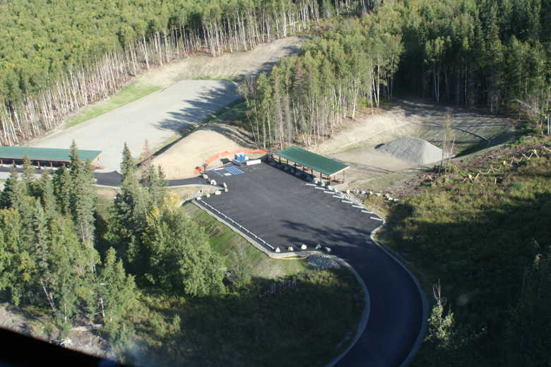
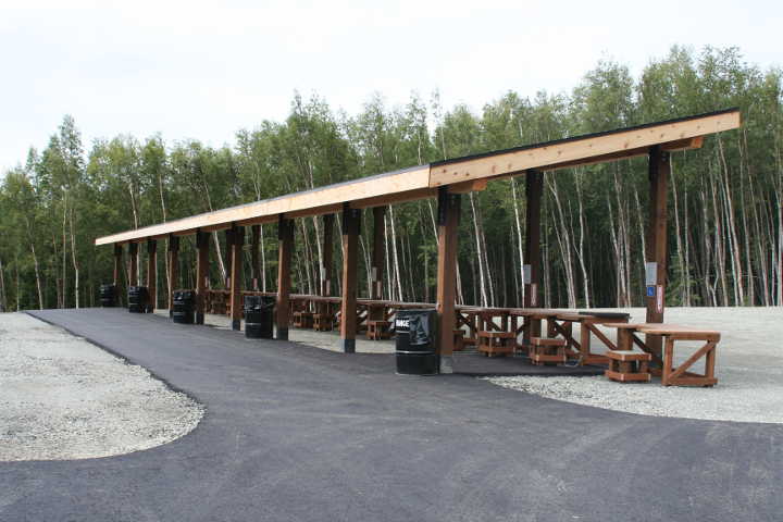
Phase II construction is complete. It's normal schedule of 10:00am to 8:00pm. The range will be closed every Wednesday. There are now 18 lanes of fire on the 100 yard range, and 10-12 lanes of fire on the 25 yard range. Parking has also been expanded and portable lavatories have been provided.
USE OF THE KENNY AND PATTI BARBER SHOOTING RANGE IS AT YOUR OWN RISK.
That being said, please ensure you have read and understood all the Range Rules (PDF) site. Both land managers and the State Troopers will cite violations of the KRPUA regulations. Please pick up your debris and remind others to do the same. Damage and maintenance costs will take away resources that could enhance the facility.
Located between Palmer and Butte Alaska, the Kenny and Patti Barber Shooting Range is off of the Maud Road Extension, approximately 2.7 miles from the end of the paved section of Maud Road. It is approximately 1000' ft. past Mud Lake with appropriate signage marking its location.
Trash cans will be provided and emptied regularly. For questions, comments, and/or concerns about the KRPUA, or to receive information about current and upcoming projects and/or events taking place on state owned land within the KRPUA contact Travis Jensen at 269-8503 or email: Travis Jensen (travis.jensen@alaska.gov)
Kenny and Patti Barber Shooting Range Statistics
| # of Users (P) Personally Seen | # of Users (R) Reported | # Bags of Trash | # of Vehicles | # of ATV's |
|---|---|---|---|---|
| 1,705 | 15,425 | 598 | 6,911 | 31 |
| Total Visits = 17,130 | ||||

Photos

|

|

|

|

|
|

|
|
|
Fish and Wildlife Habitat
 The Knik River Public Use Area (PUA) is home to a wide variety of different habitat types including glaciers, ice fields, braided river channels and exposed shorelands, high elevation mountains, alpine and sub-alpine tundra, boreal forests, creeks and floodplains, and a sprawling lakes and wetlands complex. Each of these habit types help to influence the areas rich and diverse fish and wildlife populations. For more information on the different types of fish, birds, and animals found throughout the PUA visit the Alaska Department of Fish and Game's Wildlife Notebook.
Fish that are common to the area include Sockeye salmon (Red), Coho Salmon (Silver), and Chum Salmon. Salmon are anadromous which means that they migrate from saltwater to spawn in fresh water. Resident freshwater species of Dolly Varden and a fish not often seen because of its small inconspicuous markings is the Slimy Sculpin are also found throughout the Knik Valley.
The most popular fishery in the PUA is Jim Creek. Large runs of silver salmon migrate up Jim Creek to reach the streams of the lakes and wetlands complex. These lakes include Mud Lake, Jim Lake, Gull Lake, Swan Lake, Leaf Lake, and Chain Lakes. The expansive lakes and wetlands provide ideal habitat for the rearing of anadromous fish.
 The PUA is home to a wide variety of animals including big game, small game, and furbearers. Big game animals found in the area include, Moose, Black Bear, Brown Bear, Dall Sheep, and Mountain Goat. Some examples of small game animals found in the area include Hares, Porcupine, Shrews, and Voles. Common furbearing animals of the area include Beaver, Coyote, Lynx, Marmot, Marten, Mink, Muskrat, Northern Flying Squirrel, Red Fox, River Otter, Weasels, Wolf, and Wolverine.
There are many different kinds of bird species that visit the PUA. A species list of these birds can be found in the "Birds of Jim-Swan (PDF)" checklist. Some of the more recognized birds seen in the PUA include Trumpeter Swans, Ducks, Eagles, Ravens, Owls, and Accipiters.
Trails
The Knik River Public Use Area (PUA) has an extensive system of trails, most of which are multiple-use. Nearly every trail in the PUA was created over the course of time as a result of unplanned social use. Some trails were created to access hunting and trapping areas, other trails were created for the purpose of recreation, and still others were developed for the purpose of resource extraction. The most well known trail leaves the trailhead and travels 25 miles up towards the Knik Glacier. The trail is more of a route than a designated pathway.
| RST 17 Trail Reroute | Rippy Trail Fall Colors | |

|

|
Maps and Brochures
| Knik River Public Use Area (PDF) | Knik River PUA Land Status (PDF) | |

|

|
|
| Knik River PUA Management Units (PDF) | Knik River PUA Shooting Restrictions (PDF) | |

|

|
|
| Knik River PUA Brochure (PDF) | Knik River Google Map | |
 |
 |
|


 One of the most popular attractions of the Knik River Public Use Area (PUA) is Jim Creek, a well-known site in the Matanuska-Susitna Valley, and a popular destination for folks who enjoy being outdoors, camping, and riding Off-Highway Vehicles (OHVs); during late summer Jim Creek is recognized for its exceptional fishing opportunities. The area is also recognized for its checkered past where chronic unlawful problems were the norm. Underage drinking parties, car burnings, indiscriminate target shooting, wildfires, garbage dumping, and abuse of natural resources gave the area a bad name, and salty reputation. In 2004 local residents, responsible outdoor enthusiasts, special interest groups, and local legislators joined forces to find a solution to the trouble happening on public lands in the area, and subsequently the Knik River Public Use Area was born.
The PUA was signed into law on June 30, 2006 by Governor Frank Murkowski, and the legislation gave management authority to the Alaska Department of Natural Resources, Division of Mining, Land, and Water. The legislation was explicit in that the PUA can not be managed as a unit of the state park system. A major component of the legislation required the Alaska Department of Natural Resources (DNR) to develop a management plan for the area. Beginning in September of 2006 a management planning process commenced, and in September of 2008 the Knik River Public Use Area Management Plan was adopted by the commissioner of DNR. Public meetings were held on multiple occasions throughout Palmer, Wasilla, and Anchorage to identify and address the comments and concerns of area users, local residents, and special interest groups.
The Knik River Public Use Area Management Plan (Plan) describes how the Alaska Department of Natural Resources (DNR) will manage state owned lands within the PUA boundaries. The Plan provides specific guidance for the management of different uses in the PUA, particularly multiple-use recreational activities. Public access within the PUA is an important issue, and the Plan provides guidance on the management of present and future trails. The Plan also makes recommendations for development of facilities such as boat launches, rifle ranges, parking areas, and campsites.
 The planning area is over 260,000 acres in size (approx. 400 square miles). Within the planning area, approximately 60,000 acres of public land are owned and managed by the federal Bureau of Land Management (BLM). These BLM lands include Wolf Point and the Friday Creek drainage on the north side of the Knik River, and the Hunter Creek drainage on the south side of the river. The BLM is slated to convey these lands to Eklutna Native Corporation in the future. There are eight (8) private parcels of land located within the planning area, including one native allotment in the vicinity of Swan Lake. The other private parcels are found in the Friday Creek area, and up near the Knik Glacier by Metal Creek.
Management recommendations and policies developed through the plan will apply to state owned lands within the boundary of the PUA. The plan does not apply to federal, Native Corporation, or private lands.