
Stream Crossing Initiative
Brown Trout. Credit: USFWS
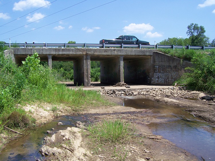
Few people consider the effects of culverts, utility crossings, and other infrastructure on the quality of stream habitat. Stream conditions may be quite different upstream and downstream of a stream road crossing, and may look different during low or high water. The design and condition of a stream crossing determine whether a stream behaves naturally and whether animals can migrate along the stream corridor.
Fortunately, we have learned how to design stream crossings that allow wildlife unrestricted access to a watershed, maintain natural stream conditions, and help protect roads and property from some of the damaging effects of floods. Peruse this website and the stream crossing handbook to learn more about corssings, their impacts and design.
Georgia’s Stream Crossing Handbook is available for download!
The southeastern United States is home to an incredibly large number of stream miles and extraordinary diversity of fish and wildlife. Fishing opportunities usually lie within only a few miles of home. Yet, despite the abundance of streams and fish, the southeast has one of the highest fish imperilment rates in the world owing in part to habitat fragmentation of aquatic species. Stream-road crossings are one of the leading contributors to habitat fragmentation.
Natural resource agencies have worked closely with the Army Corps of Engineers to develop and implement regulations that are intended to improve the safe passage of wildlife. Unfortunately, new stream-road crossings that were surveyed following the inception of the regulations show that crossings continue to fragment habitat and rarely meet the regulations. This handbook was produced, in part, in response to these surveys.
This handbook is intended for general audiences, including consultants, county engineers, back-hoe operators, students, and regulators. Intended as a nontechnical handbook, we generally outline the importance of stream continuity for aquatic and terrestrial wildlife and highlight examples of wildlife passable and impassable crossings in Georgia. Regulations are also reviewed in general terms, and examples are provided to illustrate the intent of the regulations as of this publication date. This publication does not supersede any publication or regulations produced by the Army Corps of Engineers.
It is our hope that sharing this handbook will help prevent future species declines and ensure fishing opportunities in streams for generations to come. Please download the handbook by clicking the icon to the right.
Culverts in your neighborhood. Can wildlife safely pass through them?
Wildlife need to move upstream and downstream safely so that they may access coldwater habitat, breed, access high quality food resources, and recolonize previously impacted habitats. Of the 70,000 miles of creeks and rivers in Georgia, nearly all have habitat that are affected adversely by culverts But how do you know if the culvert in your neighborhood is passable by fish? That can be a tricky question because it depends on the condition of the culvert and the size and swimability of the fish of interest. One method occasionally used as a screening tool for fish passage is the Filter method, adapted from the US Forest Service and thesis work conducted by Seth Coffman. Click this link to learn more

Should a culvert be retrofitted or replaced?
Most stream crossings in Georgia were designed and installed at a time when the environmental impacts of such crossings were not understood. Even effective but aged crossings may need to be upgraded or replaced because they have weathered decades of floods and erosion. Periodic upgrading of bridges, culverts, and roads is often required to keep crossings safe and effective. Repairing or replacing deteriorated culverts is not always as straightforward as installing a larger pipe. Read more in Georgia’s Stream Crossing Handbook.
Similarly, some crossings need to be removed or retrofitted to facilitate the passage of aquatic organisms. There are tens of thousands of crossings in nearly every southeastern state. Which are the most important ones to replace? With very limited dollars available, how does one choose among the abundance of options. While the Filter Method helps as a field screening tool (see above), additional work is necessary to narrow the list. For that reason, USFWS has embarked on a field and GIS based assessment of habitat fragmentation in three major watersheds in the southeast. This initiative incorporates our understanding of species distribution, channel morphology, and the potential importance of a culvert, dam, or impoundment in the context of the watershed’s natural connectivity. This project is funded in part through the Federal Highways Administration. More information is available by contacting Will Duncan (Will_Duncan@fws.gov).
Permitting
Permitting Overview: When planning to work in navigable waters of the United States, including wetlands, a permit from the U.S. Army Corps of Engineers must be obtained. To read a general overview of the process, please visit the Corps’ website: http://www.sas.usace.army.mil/Missions/Regulatory/Permitting.aspx
Regional Conditions: Fish-passable road-stream crossings have been engineered for years in many states, and Georgia is now among a growing number of states with policies aimed at producing fish passble crossings. These policies are called Regional Conditions. They are updated periodically and can be found on the U.S. Army Corps of Engineers website: http://www.sas.usace.army.mil/Portals/61/docs/regulatory/NWP_Regional_Conditions.pdf
Regional Conditions USFWS Guidance Document: This document provides additional guidance and clarification to the Savannah District 2007 Nationwide Permit Regional Conditions for culvert Pre-Construction Notifications. It is NOT intended to replace the Regional Conditions. It also highlights common additional information needs that are often missing from PCNs, but are necessary for the U.S. Fish and Wildlife Service and the Army Corps of Engineers to evaluate conformity with the Regional Conditions.
Examples of Fish Passable Crossings


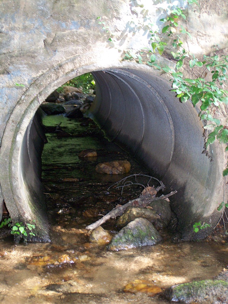
Examples of Impassable Crossings


Examples of Wildlife affected by crossings


Try our embedded culvert area calculator
Useful Links for Stream Crossings
Fish Xing: Software and learning systems for fish passage through culverts
Fish Xing: Resources and Literature
Fish-friendly stream crossing website- U.S. FWS Midwest Region

