Data Center
Information Center
USGS in Your State
USGS Water Science Centers are located in each state.

Connect with USGS
|
Ice Formations on selected North Dakota Rivers and Streams, 2010-11 Winter 

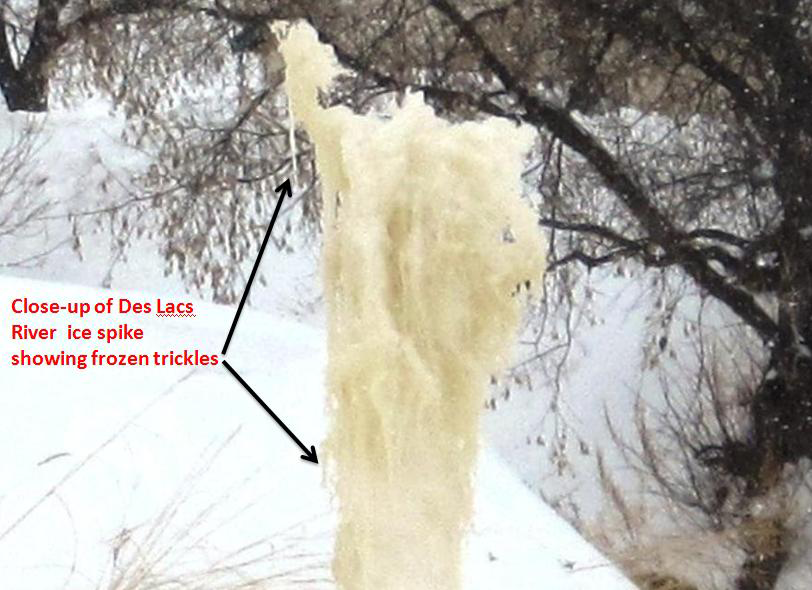
Ice Spike at Des Lacs River, near Foxholm, ND.
The 2010-11 winter conditions in North Dakota provided the proper environmental setting for the development of some of Nature’s unique features – ice formations. The ice formations shown in these photographs were found near USGS streamgages on selected rivers and streams in North Dakota by USGS personnel during site visits. Some formations were photographed over successive months by USGS personnel visiting these sites.
How were these ice formations created? According to ice spike expert, Dr. Stephen Morris of the University of Toronto these formations are like the ice spikes seen in ice cube trays in lab experiments. Ice spikes that are produced in control environments are “caused by the rapid freezing and expansion of water molecules in a confined space. Also pure water provides the best condition for the formation of ice spikes”. The small ‘humps’ that appear on top of ice cubes in a tray in a refrigerator are an example of how ice spikes start. The ice formations found in nature “are like lab ice spikes in that there is a small, hollow pipe-like structure [similar to a drinking straw] within the formation. But unlike conventional ice spikes, expansion on freezing is not crucial.” In the case of the ice formations in nature, “the flow just pushes water up the formation so that it freezes as it emerges, enlarging the ‘pipe’. There can’t be any open water nearby for this mechanism to work and that a rapid freeze helps.”
The winter conditions at each of the ice formation’s locations were similar:
- Freezing or sub-zero temperatures and low flow in channel during winter months
- Ice covered the surface of the stream and accumulated at depths long the banks restricting flow
- In each instance, water flowed over a structure such as a weir or beaver dam causing turbulence in the flow
- Due to the turbulence and restriction in flow, water emerged from small surface openings downstream of the structure and began to freeze – probably rapidly in some cases due to the sub-zero temperatures at times
- Whether the freezing water resulted in a “columnar” or a “frothy, bubble” ice structure depended on the unique conditions at each location and the weather conditions over time
Definition: A weir is a small dam in a stream designed to divert its flow through a desired channel. In this case so streamflow can be measured during low flow conditions.
06339100 Knife River at Manning, North Dakota
- Site located in west-central North Dakota in the Knife River Basin
- Large “bubble-like” ice formation up to 3.8 feet tall observed by USGS personnel December 2013
|

December 12, 2013 - Looking upstream on the Knife River at Manning, North Dakota.
Flow is 2.5 cubic feet per second.
|

December 12, 2013 - Looking upstream on the Knife River at Manning, North Dakota.
Flow is 2.5 cubic feet per second.
|
|
05100000 Pembina River at Neche, North Dakota
- Site located in northeast North Dakota in the Lower Pembina River Basin
- Large ice circle formation observed by USGS personnel October 2013
- Ice circles are a natural phenomenon that occur in slow moving water in cold climates.
|

October 30, 2014 - Looking downstream on the Pembina River at Neche, North Dakota.
Flow is estimated at 131 cubic feet per second.
|
|
05116500 Des Lacs River at Foxholm, North Dakota
- Site located in north-central North Dakota in the Souris River Basin
- Smaller ice “spikes” first noticed by USGS personnel in December 2010
- One large columnar “spike” about 7 feet tall and several smaller “spikes” observed January 2011
- Ice “spikes” disappeared between January and February 2011
- Another ice formation is observed developing at the same location in March 2011
|

November 4, 2010 - Open-water conditions at weir.
Flow is 15.9 cubic feet per second.
|

December 13, 2010 - Weir and river are icing over.
Start of small ice spikes (estimated height about
1 foot) downstream of weir. Flow is 10.6 cubic feet
per second.
|

January 24, 2011 - Several smaller ice spikes merge
to create a large ice spike. Flow is 5.59 cubic feet per
second.
|
|

January 24, 2011 - Estimated height of
large ice spike is about 7 feet.
|

February 17, 2011 - Increase flow in the
Des Lacs River and warmer temperatures probably
caused instability in the area of the ice spikes
causing them to disappear.
|

March 7, 2011 - New ice formations observed forming
below weir at Des Lacs River near Foxholm, North Dakota.
|
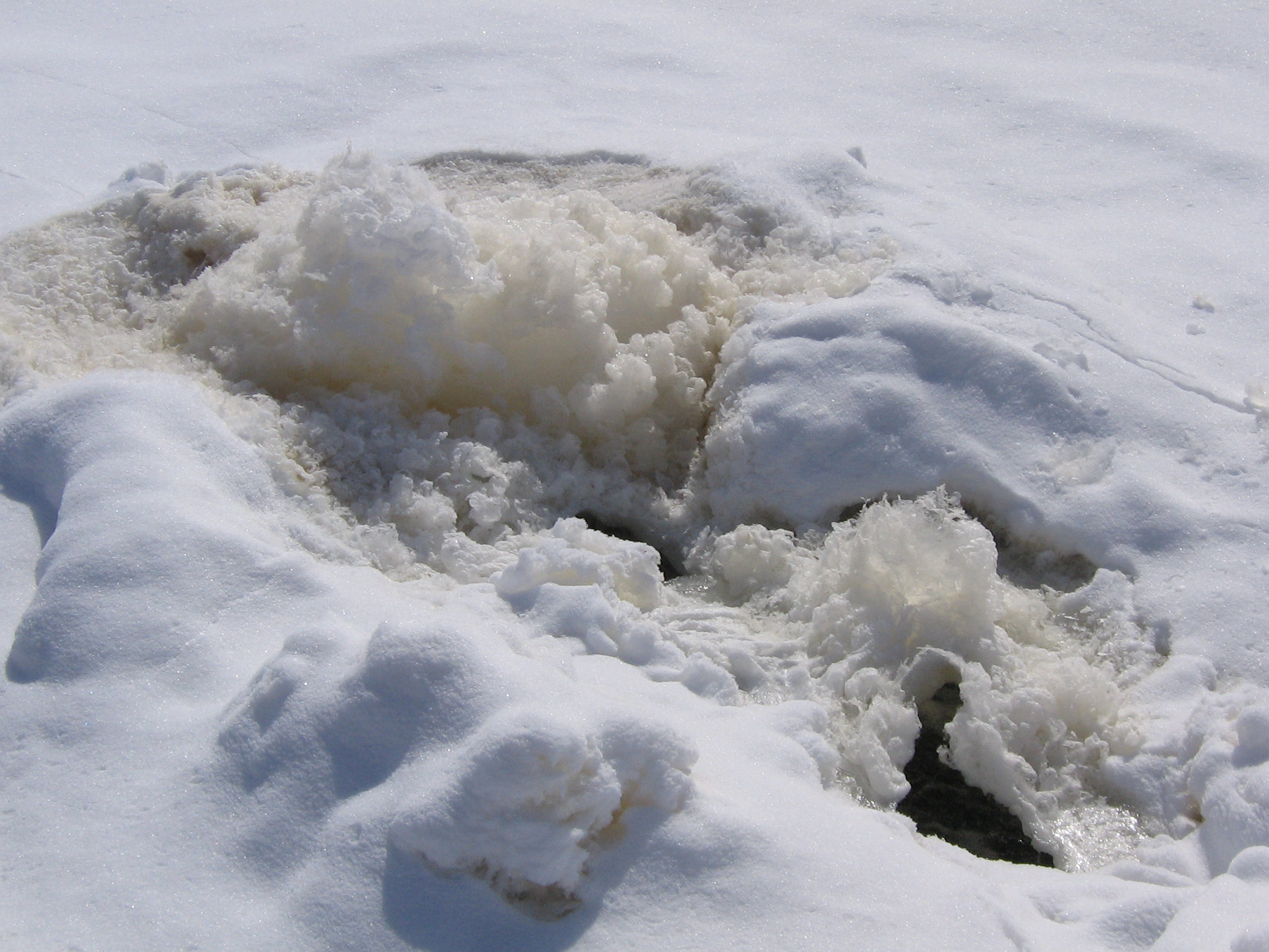
06347500 Big Muddy Creek near Almont, North Dakota
- Site located in south-central North Dakota in the Heart River Basin
- Large “bubble-like” ice formation between 5-6 feet tall observed by USGS personnel March 2011
- “Bubbles” observed coming from opening near top of formation denote the existence of a straw-like feature inside formation
|

October 6, 2010 - Looking downstream toward beaver
dam on Big Muddy Creek near Almont, North Dakota.
Flow is 4.40 cubic feet per second.
|

March 3, 2011 - USGS personnel (5'8") stands next
to ice formation at Big Muddy Creek. Flow is 6.45
cubic feet per second.
|
|
06349500 Apple Creek near Menoken, North Dakota
- Site located in south-central North Dakota in the Apple Creek Basin.
- Small “mound-like” formations observed by USGS personnel January 2011
- Ice “spike” between 2-3 feet tall observed developing just upstream of ice mounds and below snow-covered weir March 2011
|

November 2, 2010 - Open weir at Apple Creek near
Menoken, North Dakota. Flow is 36.7 cubic feet per second.
|

January 13, 2011 - Small ice mounds developed
downstream of weir on Apple Creek. Flow is 14.7 cubic
feet per second.
|

March 10, 2011 - A columnar ice spike is observed
developing between the ice mounds and weir at
Apple Creek. Flow is 20.5 cubic feet per second.
|
|

March 10, 2011 - Ice formations forming at Apple Creek.
|

March 10, 2011 - Marker (3' 10") stands next to ice
spike at Apple Creek near Menoken, North Dakota.
|
|